|
» Herringmarket » Farm the "Stamper" » Farm Saint Christopher » House "de Grote Sterre" » House Saint John » Damme town hall » Slekkeput » Saint-John's hospital » Medieval waterwell » Lock of the Lieve » Waterpumps » Statue J.Van Maerlant » Casemates » Schellemill » Our Ladies Church » NR Damme town walls » Damse Vaart » Bat reserve » Leopoldcanal » Schipdonkcanal » Damme book village » Museum St-John's hospital » Museum town hall » Museum Schellemill » Town walls » NR Damme town walls » Bruges Gate » Casemates » Fort Saint Donaas » Fort of Bavaria |
Damme town walls
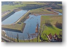
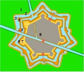
The 80-year war between the Northern Netherlands and Spain was the reason for the construction of the bastion Damme. Between 1615 and 1620, the Spaniards erected a new defence girdle around the town in the form of a 7-star. Damme was important to the Spanish because of it's position on the net of canals, because it was close to the hostile town of Sluis and because it was ideally positionned to defend Bruges. The mouth of the canal the "Lieve" (linking Ghent with Damme) was diverted inside the town and entered Damme now via a covered watergate (see casemate). That gate was used lateron as a storage for ammunition and still can be seen. Due to the construction of these new town walls, several old buildings (such as the old city gates (see Bruges Gate)) had to be pulled down. From that moment on, the town could only be entered via two new gates. A military governor ruled the town (or better: fortress) and Damme would remain a military stronghold until 1760. In 1786, the grounds of the bastion were sold publically. The double defence girdle is still very well visible, though suffered a bit from the influences of nature. A large part of the walls is owned by the vzw Natuurpunt (an organisation for nature preservation). The object is to entirely restore the walls around Damme. In 2001, a part of the girdle was restored and during the excavations, the remains of an old construction were found (see Bruges Gate). The walls have now become a nature reserve where several (some very rare) species of plant- and animalwildlife have found an ideal habitat. The reserve measures about 55 ha. A walk alongside the walls is more than worth your while.
Below digital pictures can give you a better idea on how the defence walls around Damme would have looked like in 1650.
|
|
 Location:
around the centre of Damme, 8340 Damme [gps]
Location:
around the centre of Damme, 8340 Damme [gps]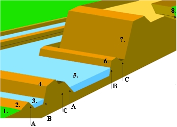
 1.
field
1.
field